-
Conservation in Practice
24
-
Sep 27, 2024
2024 at TfW
Sep 27, 2024
-
Jan 9, 2024
2023 at TfW
Jan 9, 2024
-
Jan 8, 2024
Reflections on 2023
Jan 8, 2024
-
Dec 26, 2023
My First Job: Lessons, Skills, and Memories with TfW
Dec 26, 2023
-
Apr 12, 2023
Field Work as a Woman
Apr 12, 2023
-
Mar 24, 2023
Corporate Medical Insurance
Mar 24, 2023
-
Jan 9, 2023
2022 at TfW
Jan 9, 2023
-
Nov 18, 2022
When I see an elephant ___
Nov 18, 2022
-
Nov 14, 2022
Comms. for Conservation
Nov 14, 2022
-
Sep 9, 2022
On moving to Goa
Sep 9, 2022
-
Feb 4, 2022
On Hiring at TfW Foundation
Feb 4, 2022
-
Dec 1, 2021
Persevering with PARIVESH
Dec 1, 2021
-
Jan 7, 2021
Choosing a laptop in 2021 (and a mini anti-Apple rant)
Jan 7, 2021
-
Oct 12, 2020
Helping Ensure Ethical Indian Drone Operations
Oct 12, 2020
-
Jun 10, 2020
26 projects approved by the Indian National Board of Wildlife on April 7th 2020
Jun 10, 2020
-
Apr 18, 2020
Civilian technologists should assist the state during the COVID-19 pandemic
Apr 18, 2020
-
Feb 22, 2020
Working on our Unusual Solution: The Ethics of Drone Use
Feb 22, 2020
-
Oct 23, 2019
Report: The Role of Technology in Conservation in India | SCCS-Bangalore 2019
Oct 23, 2019
-
Jun 26, 2019
On ghost gear and seaweed stirfry
Jun 26, 2019
-
Apr 11, 2017
Careful planning for an eco-friendly road network
Apr 11, 2017
-
Apr 26, 2016
India’s Hydropower Investments in Bhutan: Environmental Impacts and the Role of Civil Society
Apr 26, 2016
-
Oct 15, 2015
Let’s open up the skies for drones
Oct 15, 2015
-
Nov 17, 2013
S696, Maps and Atlases: The Cambridge Map Room
Nov 17, 2013
-
Dec 6, 2011
Mapping for the Protection of India's Environment and Forests
Dec 6, 2011
-
How-to-?
28
-
Sep 2, 2024
Demystifying DashWare
Sep 2, 2024
-
Aug 19, 2024
Understanding Drone Orthomosaics
Aug 19, 2024
-
Aug 19, 2024
Creating a Mapping Mission
Aug 19, 2024
-
Aug 14, 2024
Planning Photo and Video Missions for UAVs
Aug 14, 2024
-
Jun 19, 2024
The Practical Nuances of Calculating Field of View
Jun 19, 2024
-
Jun 12, 2024
Calculating Object Sizes in Drone Images
Jun 12, 2024
-
Sep 28, 2023
Mapping Floods: Exploring Thresholding Methods
Sep 28, 2023
-
Sep 20, 2023
Identifying Forest Fire Scars with GEE
Sep 20, 2023
-
Oct 10, 2022
Google Earth Engine vs. the Microsoft Planetary Computer
Oct 10, 2022
-
Oct 4, 2022
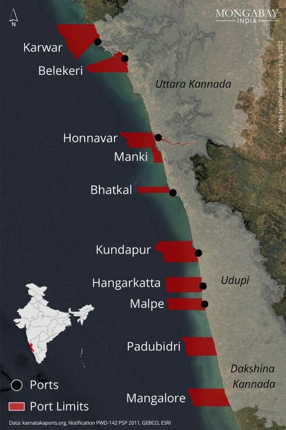
Mapping port development in Karnataka
Oct 4, 2022
-
Aug 31, 2022
Using PARIVESH for effective conservation advocacy
Aug 31, 2022
-
Jun 6, 2022
Using Open Data Kit (ODK) in the field
Jun 6, 2022
-
May 9, 2022
How-To: Carry UAVs through Indian airport security in 2022
May 9, 2022
-
Dec 22, 2021
Tracking Air Pollution
Dec 22, 2021
-
May 28, 2021
Using Computer Vision to Identify Mangrove-containing pixels in Satellite Imagery
May 28, 2021
-
Jan 7, 2021
Using Google Earth Engine to map mangroves in Goa
Jan 7, 2021
-
Oct 7, 2020
How we use Excel for geospatial data analysis and visualisation
Oct 7, 2020
-
May 25, 2020
Using drones to assess above-ground carbon stock
May 25, 2020
-
Jul 20, 2019
Assessing Ecosystem Carbon using Drones: The State of the Art
Jul 20, 2019
-
Mar 26, 2019
Assessing Carbon using Satellite Imagery: the Math and Maps behind Ecosystem Valuation.
Mar 26, 2019
-
Jan 29, 2019
Calculating a drone camera's image footprint OR How I learned to love tan again.
Jan 29, 2019
-
Jan 23, 2019
Analysing Drone and Satellite Imagery using Vegetation Indices
Jan 23, 2019
-
Jan 17, 2018
Drones, spatial analysis and a 3D model: Asola Bhatti WLS
Jan 17, 2018
-
Jan 16, 2018
Drones, aerial imagery, 3D models and VR.
Jan 16, 2018
-
May 20, 2014
From the Space Shuttle to a block of wood
May 20, 2014
-
Aug 5, 2013
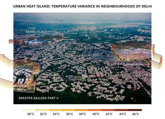
Using data from the Landsat 8 TIRS instrument to estimate surface* temperature
Aug 5, 2013
-
Jun 15, 2013
Landsat 8 data and maps of Delhi
Jun 15, 2013
-
May 3, 2013
Mapping Mandis
May 3, 2013
-
From the field
16
-
May 21, 2024
Here Comes the Drone
May 21, 2024
-
Sep 18, 2023
Mudflats to Mangroves
Sep 18, 2023
-
Apr 13, 2023
The Guardian of Mangar Bani
Apr 13, 2023
-
Dec 15, 2022
Diving Deep with ROVs
Dec 15, 2022
-
Oct 24, 2022
From Drones to Dolphins
Oct 24, 2022
-
Oct 11, 2022
Anatomy of an Unsuccessful Project: The Tiger and the Thermal Camera
Oct 11, 2022
-
Sep 14, 2022
By the river Gandak
Sep 14, 2022
-
Apr 18, 2020
August 28th (Ladakh Lakes #7)
Apr 18, 2020
-
Apr 18, 2020
High-altitude Desserts (Ladakh Lakes #6)
Apr 18, 2020
-
Apr 18, 2020
Arriving in Tso Moriri (Ladakh Lakes #5)
Apr 18, 2020
-
Mar 22, 2020
A day in the field: Chilling Tso and Ryul Tso (Ladakh Lakes #4)
Mar 22, 2020
-
Oct 11, 2019
Perceptions of Ladakh (Ladakh Lakes #3)
Oct 11, 2019
-
Oct 9, 2019
Mountains of Trash (Ladakh Lakes #2)
Oct 9, 2019
-
Oct 8, 2019
Introduction: Machine Perspectives on Alien Landscapes (Ladakh Lakes #1)
Oct 8, 2019
-
Jan 14, 2019
My first weeks with Technology for Wildlife
Jan 14, 2019
-
Aug 10, 2017
A first person account of the capture of a tiger in Northern India: Four elephants, a bulldozer and a drone.
Aug 10, 2017
-
Mongabay-India
8
-
Sep 22, 2023
Conservation Cartography with Mongabay-India (Part VIII)
Sep 22, 2023
-
Sep 1, 2023
Conservation Cartography with Mongabay-India (Part VII)
Sep 1, 2023
-
Nov 29, 2022
Conservation Cartography with Mongabay-India (Part VI)
Nov 29, 2022
-
Sep 2, 2022
Conservation Cartography with Mongabay-India (Part V)
Sep 2, 2022
-
Jul 8, 2022
Conservation Cartography with Mongabay-India (Part IV)
Jul 8, 2022
-
May 17, 2022
Conservation Cartography with Mongabay-India (Part III)
May 17, 2022
-
Mar 14, 2022
Conservation Cartography with Mongabay-India (Part-II)
Mar 14, 2022
-
Jan 21, 2022
Conservation Cartography with Mongabay-India (Part-I)
Jan 21, 2022


![[Video] Hangul, the shy Kashmiri deer, is facing the threat of extinction as its habitat shrinks.png](https://images.squarespace-cdn.com/content/v1/59fc9bdfcd39c3f5ace09221/cc19af9a-6be5-43ba-be5a-63271c3d28b8/%5BVideo%5D+Hangul%2C+the+shy+Kashmiri+deer%2C+is+facing+the+threat+of+extinction+as+its+habitat+shrinks.png)


