Mongabay-India

Conservation Cartography with Mongabay-India (Part VIII)

Our collaboration with Mongabay-India began in October 2021, with the objective of enhancing their stories with our spatial analysis expertise. This blogpost documents the articles we’ve worked on together in May and June 2023.

A hill town in Nilgiris district pays the price for poor waste management

Map of the Nilgiri Biosphere Reserve.

Kotagiri town in Nilgiris district is experiencing a rise in human-wildlife interactions due to fragmented forests, open dump sites, and landfills that attract wildlife. The Nilgiris district is landlocked in the Western Ghats region and consists of a fragmented forest area. However, it falls within the Nilgiris Biosphere Reserve, which aims to promote human-animal coexistence through its core, buffer, and transition zones.


[Explainer] What are floodplains and how have they been managed in India?

Satellite imagery of Mahad city and tehsil in Raigad district, Maharashtra, before and after heavy rains in July 2021. The tehsil and city have been built on the floodplain of the Savitri river.

India is highly susceptible to flooding, and the situation worsens due to construction in floodplains. Only a limited number of states have floodplain zoning policies, and experts emphasise the importance of implementing these laws in other flood-prone states. To visualise the impact of development in floodplains, we utilised open-source satellite imagery to study flooding in two regions of India.

Satellite imagery from 2022 of the Commonwealth Games Village built on the floodplains of Yamuna river. The venue flooded before the games in 2010.

We didn’t start the fire? Speculations over cause of Goa forest fires continue; state plans recovery

Goa experienced devastating forest fires in March 2023, resulting in the destruction of 418 hectares of land and causing significant harm to biodiversity and ecology. The cause of the fires remains uncertain, with speculation ranging from slash and burn techniques to high temperatures and scarce rainfall. Cashew farmers affected by the fires deny their involvement and seek compensation. 

Map representing burn scars obtained by analysing pre and post-fire conditions from February and March 2023, respectively.

Experts suggest preventive measures like fire lines and rainwater trenches. Over a 10 to 12-day period, 74 fire incidents were reported, affecting wildlife sanctuaries and surrounding villages. A total of 418 hectares, including forest land, were destroyed.

Despite Chamba order, stopping plantation on migratory routes of pastoralists in Himachal still a long journey

The Himachal Pradesh Forest department's Chamba circle issued an order in November 2022 acknowledging that tree plantations along migratory routes hinder pastoralists' access to quality fodder. Local pastoralists welcomed the order but called for its extension to other forest circles. The adherence to the current instructions from the grazing advisory committee to cease such plantations, have been lacking.

Migratory routes of pastoralists and the tree plantations on their path that pose as hurdles.

Afforestation activities in Himachal Pradesh have increased vulnerability for pastoralists, leading to invasive species expansion and disruption of seamless connectivity to green pastures. The Chamba circle's order aimed to address these concerns and aligns with prior research highlighting the hardships faced by pastoral communities due to hindrances in accessing green pastures during their seasonal migrations.

Migratory routes of pastoralists and the tree plantations on their path that pose as hurdles.

The information regarding pastoralists was obtained from an order by the Himachal Pradesh Forest Department. As per department records, 2,809 plantations took place in the state between January 2016 and July 2019. Data for 785 plantations were missing, as per a study. The maps represent 384 plantations in Chamba Circle with complete data.

Migratory routes of pastoralists and the tree plantations on their path that pose as hurdles.

The Dhapa land was originally part of the East Kolkata Wetlands, which serves as Kolkata’s natural sewage treatment system and was designated a Ramsar site in 2002, as a wetland of global importance.

The Dhapa landfill in Kolkata has been a source of frequent fires and declining air quality since 1987. To address this issue, the National Green Tribunal recommended biomining and bioremediation methods for waste clearance. However, progress has been slow, with only 0.78 million tonnes out of 4 million tonnes processed as of February 2023.

Landfills contribute to global warming due to methane emissions, and the target of clearing Dhapa by June 2024 is uncertain. The state government must clear the remaining 80% of waste within a year to meet the recommended deadline or face penalties. 

The landfill's fires have caused health problems, with PM10 concentration exceeding standards. Municipal solid waste landfills rank as the third-largest source of methane emissions, exacerbating fires and worsening air quality.


(Note: This is the eighth blog in the series, on our collaboration with Mongabay-India. Read the previous blog here, and the first in the series, here.) 

Conservation Cartography with Mongabay-India (Part VII)

Our collaboration with Mongabay-India began in October 2021, with the objective of enhancing their stories with our spatial analysis expertise. This blogpost documents the articles we’ve worked on together from November 2022 to April 2023. 

Hangul, the shy Kashmiri deer, is facing the threat of extinction as its habitat shrinks

Around six to seven cement factories have come up near Khrew, very close to the Dachigam National Park where the hangul is found.

The hangul population has drastically declined from an estimated 5,000 in the early 1900s to a mere 261 or possibly fewer individuals today. The decline is attributed to various factors, including habitat fragmentation caused by human activities such as urbanisation, illegal industries, mass tourism, and military presence. Cement factories, established in the mid-1980s due to abundant limestone deposits, are particularly concerning as they negatively impact the hangul's habitat and contribute to the population's decline.

We worked on a map visualising the locations of cement industries around Dachigam National Park, where the hangul is found.

India aims to go big on sugarcane-based ethanol, but water intensity of the crop throws up concerns

Map depicting sugarcane production in Maharashtra.

India aims to reduce its reliance on imported crude oil by achieving a 20 percent ethanol blending target by 2025, requiring 1000 crore litres of ethanol. Currently, ethanol is primarily produced from molasses, a sugarcane by-product, which consumes a significant amount of water. Studies suggest that converting sugarcane juice to ethanol is a more water-efficient process. In Maharashtra, sugarcane farmers are discontent with the offered price rate for the crop, payment delays, lack of transparency in weighing, and rising input costs.

Nagaland’s first bird count event spells hope for bird and wildlife documentation in the state

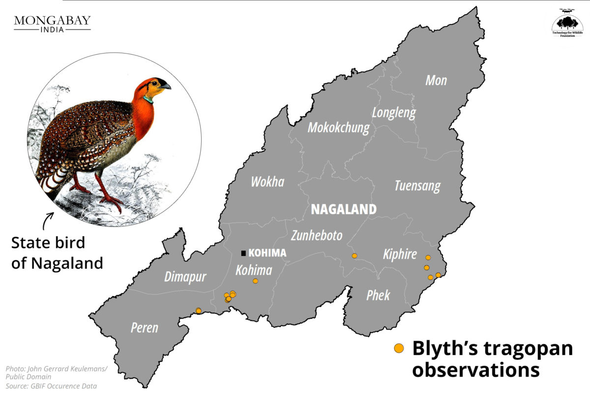
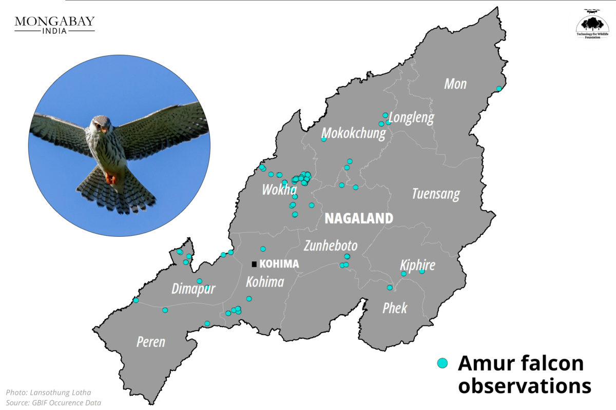
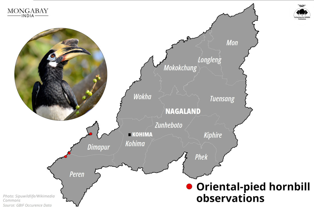
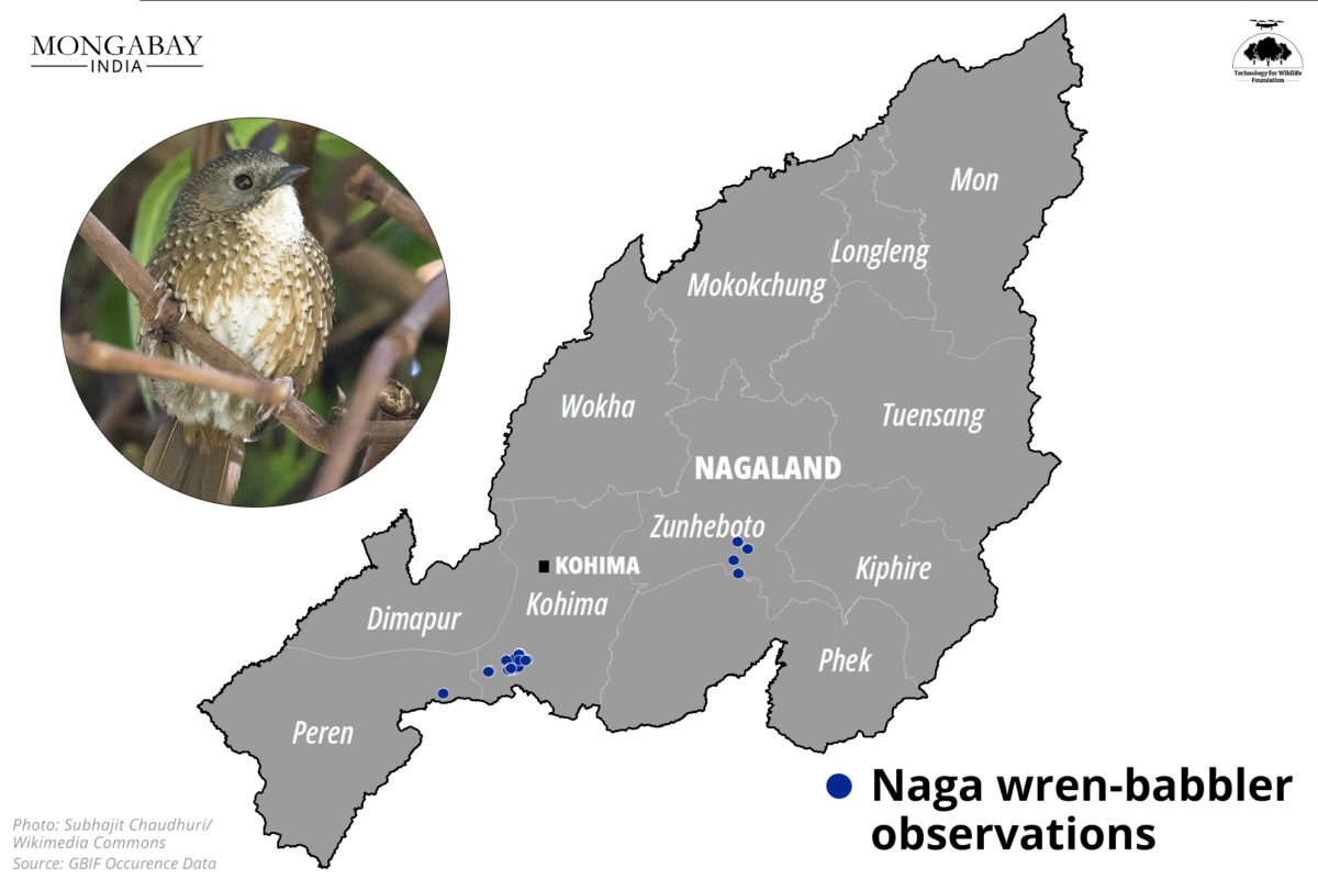
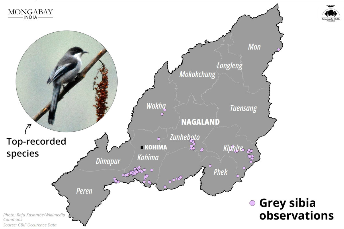
The citizen science records displayed do not indicate the comprehensive presence/absence of the species and its complete distribution. Design by Kartik Chandramouli/Mongabay.

The Tokhü Emong Bird Count (TEBC) in Nagaland, India, marked the state's first bird documentation event. Organised by Bird Count India, the Wokha Forest Division, and the Nagaland Forest Management Project, the four-day event involved 18 e-birders from four districts.

They identified 178 bird species, including notable sightings of the Amur falcon, blue-napped pitta, and brown shrike. The TEBC aimed to promote birding and conservation among young participants, with workshops on birding techniques and data uploading on eBird.

Denial of clearance to Etalin hydel project offers relief to some; may impact Arunachal’s hydropower development plan

Hydropower projects proposed in the Dibang watershed in Arunachal Pradesh. The red markers indicate the Etalin HEP envisaged as a run of the river scheme on rivers Dri and Talo in the Dibang Valley district.

The Etalin project, located in a biodiversity-rich area, has sparked controversy due to its potential environmental impact. The Forest Advisory Committee (FAC) refused to grant the Stage-II or final forest clearance, considering the numerous concerns raised through representations. The decision was influenced by Arunachal Pradesh's recent inability to declare a national park in the same valley where another mega dam has been approved for construction. The map visualises the proposed hydropower projects in the Dibang watershed, with the Etalin project marked in red.

Urban and peri-urban farming can play a small role in reducing carbon footprint

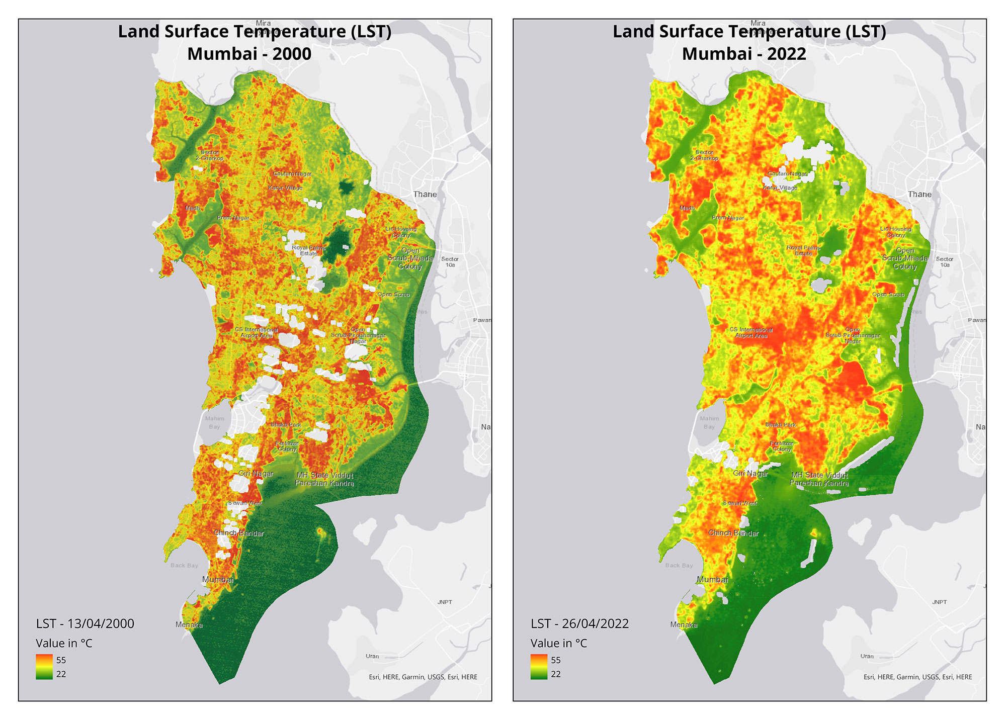
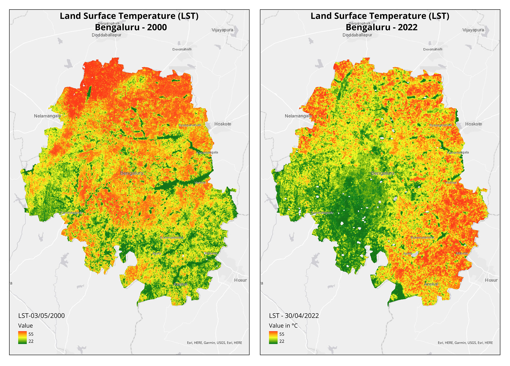
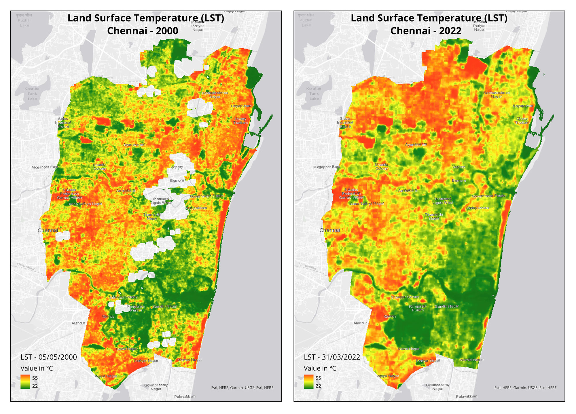
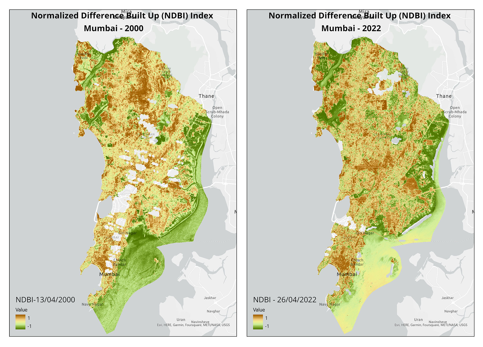
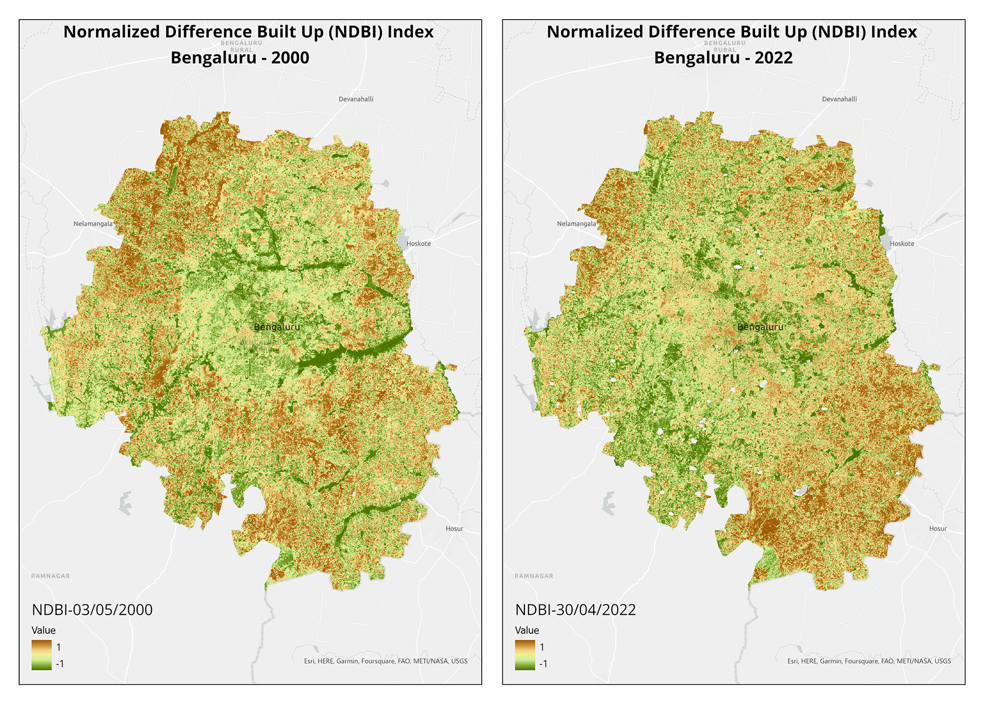
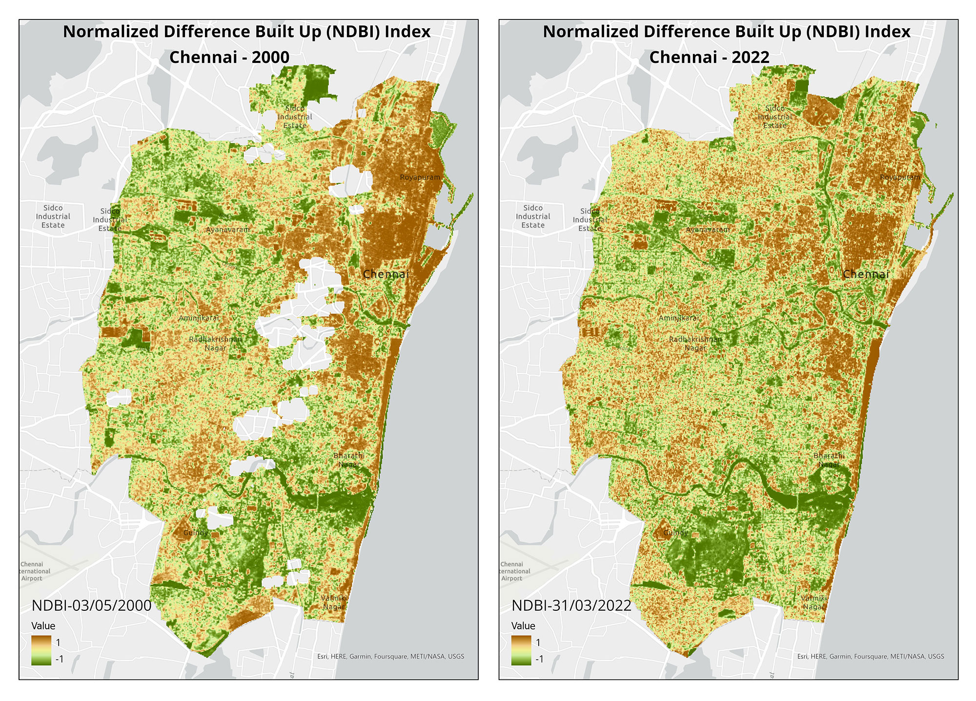
Urban and peri-urban agriculture (UPA) is gaining popularity in Indian cities as a means to promote climate action and sustainable development. While the climate mitigation impact of UPA may be limited, a study from IIT-Madras suggests that it can contribute to increasing carbon stocks and reducing land surface temperatures in urban areas. 

Beyond climate benefits, UPA has additional advantages for urban planning, including enhancing individual and community well-being, improving urban food security, and generating green job opportunities. Maps accompanying this article visualise the potential effect of UPA on build-up areas and land surface temperatures in Mumbai, Bengaluru, and Chennai.


(Note: This is the seventh blog in the series, on our collaboration with Mongabay-India. Read the previous blog here, and the first in the series, here.)

Conservation Cartography with Mongabay-India (Part VI)

Our collaboration with Mongabay-India began in October 2021, with the objective of enhancing their stories with our spatial analysis expertise.  This blogpost documents the articles we’ve worked on together from July 2022 till the present. 


Karnataka’s port-development spree ignores coastal communities’ concerns

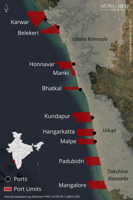
Eastern, northern, and southern limits of minor ports limits as defined by the Government, along the coast of Karnataka. Port limits for Tadri and Pavinakurve were unavailable.

Karnataka is accelerating its port-led model of development in an attempt to attract investors to the state. However, this strategy impacts those who live close to the site of proposed developments. At least three ports currently being built have encountered issues due to community opposition.

The state has one major port and 12 minor ports under different stages of development; the map locates these ports and their port-limits. This was the first in a three-part story on port development in Karnataka.


A road for a port cuts through the livelihoods of fisherwomen in Uttara Kannada

Map on the road connecting the ongoing Honnavar port project.

The second story in a three-part story on port development in Karnataka focused on the proposed port at Honnavar, where a road of around four kilometres long is being constructed. The entire stretch is the fish-drying ground of the coastal communities, and part of the proposed road also cuts through forest land. 

As part of the village coastal commons, they have been used by fishers over generations for drying fish; construction of the road would impact the livelihood of over 2,000 community members.


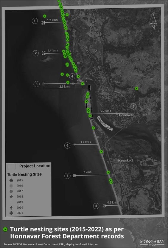
An upcoming port in Karnataka is shrinking space for olive ridley turtles

Turtle nesting sites (2015-2022) as per Honnavar Forest Department records. 

The last story in the three-part story on port development in Karnataka lists the discrepancy between the turtle nesting sites as reported by the Honnavar Forest Department, and that presented to the public by the National Centre for Sustainable Coastal Management (NCSCM). In brief, the NCSCM actually indicates that the turtle nesting sites are in the Arabian Sea; Olive Ridley turtles, like all sea turtles, nest on land. Our analysis indicates that the NCSCM made a basic conversion error when converting latitude-longitude pair values from one format to another, which was not identified before publication of their report.


Stubble burning is back, smothering north India with concerns for the upcoming winter

Crop burning instances in the Indo-Gangetic plains in 2021 and the PM2.5 levels during the same period.

One of the main causes of air pollution over the national capital region (NCR) and other areas of the Indo-Gangetic plains has been stubble burning. This is the practice of setting fire to straw stubble to clear fields before the new crop is seeded. The story notes that the number of incidences of stubble-burning so far is greater than it was at this time last year, despite claims by officials that they are prepared to handle the now-annual catastrophe. 

We prepared a visualisation using spatial data on fires and consequential PM 2.5 levels in the region, with each red pixel representing an area that contains actively burning fires. The grey pixels indicate PM 2.5 levels, the darker pixels leaning towards severe AQI. 


Mizoram youth protest against the national highways widening project

NHIDCL, which comes under the Ministry of Road Transport and Highways, is currently carrying out widening work on four national highways in the state – NH-09 (Seling- Zokhawthar), NH- 102B (Keifang-Manipur), NH-302 (Lunglei-Tlabung) and NH-54 (Aizawl-Tuipang).

The National Highways and Infrastructure Development Corporation (NHIDCL) has been criticised by environmental activists in Mizoram for ignoring environmental rules and regulations when working on highway projects in the state. According to the environmentalists, these initiatives have negatively impacted the environment, including damaging the state's water resources. The map we created to accompany this story depicts the four national highways in the state where the NHIDCL is currently carrying out widening work.


(Note: This is the sixth blog in the series, on our collaboration with Mongabay-India. Read the previous blog here, and the first in the series, here.)