uavs

By the river Gandak

In March, 2022 I was thrilled to find out that we were headed for a field trip to Bihar. I was excited for many reasons, including that this was going to be my first field trip with Technology for Wildlife Foundation - the experience of travelling to Bihar, encountering gharials and dolphins, the beauty of the Gandak (tributary of Ganga) and my first drone flight. The trip aimed to study the behaviour of gharials and Ganges river dolphins in the Gandak river during pre-monsoon season when the water levels of the river are shallow.

On the 15th of April, 2022, my colleagues and I left for our field trip to Bihar. We landed in Patna early that day and were later joined by our collaborators from Wildlife Conservation Trust (WCT). Together, we started for Bagaha - our field site, an amazing seven hour drive from Patna. It was the peak of summer and we needed to constantly hydrate ourselves. I was slightly tired of the heat and was trying hard to keep awake. Nevertheless, the Gangetic floodplains kept me in awe for the most part.

The next morning we left to survey the river after having chai and chole puri for breakfast. After setting up the boat with a CPOD (Cetacean and Porpoise Detection) to collect data on dolphin frequencies and other activity in the area, all of us hopped onto the boat to begin our survey. Our objective was to identify a good stretch of the river which could be the field site, a site with a good number of gharial and Gangetic river dolphin sightings. This boat ride was especially beautiful and memorable. We were in the middle of the vast stretches of the Gandak and its floodplains. The quietude of the Gandak was addictive. At one point, there was a large enough sandbar for us to hop-off the boat, where we tried flying a kite as the wind was on our side. The idea was to mount a camera and a GPS device to track the route to record features in such terrains. This was so much fun; we would probably try mounting the camera on our next field trip. The halt lasted for a good half an hour, after which we resumed the survey. By the evening, we were able to finalise the field site. We also spotted many birds, some turtles and gharials (thanks to binoculars), and a few dolphins! The day came to an end with a beautiful sunset by the river Gandak.

Our ride in the river Gandak. Image: Nancy Alice/ TfW

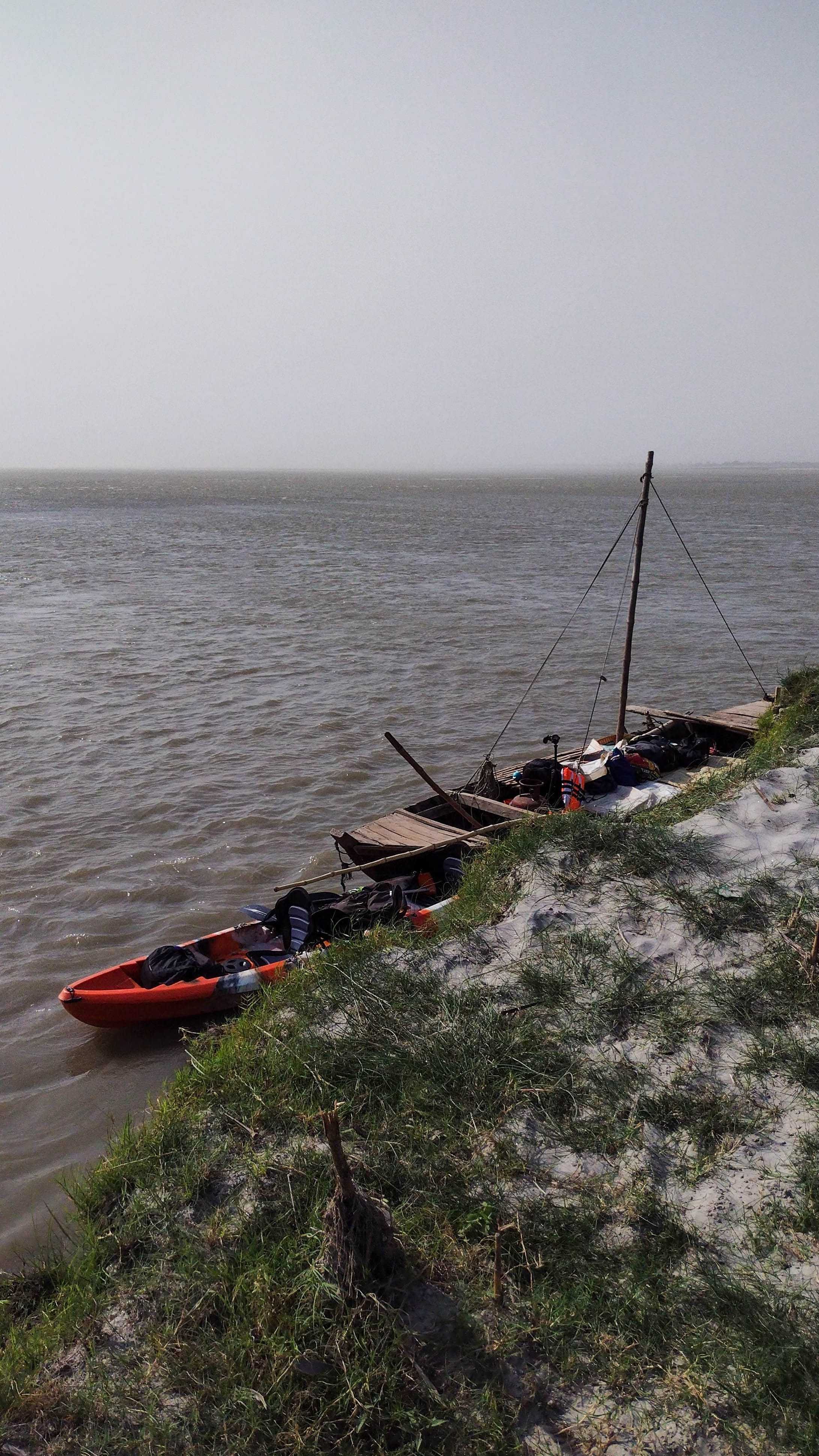
Our ride in the river Gandak. Image: Nancy Alice/ TfW.

The following day we arrived at the field site and prepped to fly the drones over gharials basking under the sun. We didn’t mean to disturb them but they were quite sensitive and would promptly glide back into the water when they heard our activities. We worked out how to operate our drones  and observed them happily without creating any disturbance. Drone-flying seems like an elegant art, from setting its orientation, launching it to getting it back to us. After a few flights by colleagues to observe gharials, I was prompted to fly it back home, with a brief primer on the controls. This was my first attempt with the drone and I was still learning how to navigate it. The toughest part though, was not being able to see the screen under such sunny conditions, and to keep a track of the battery. One of my colleagues, Shashank kept referring to video games as the best practice to have a better understanding of drone controls. Hence, video games and drone flying are up next on the bucket list for me. 

Most gharial captures were smooth as they would be basking on the sandbars, so they were clearly visible. The dolphin captures were comparatively more spontaneous and calculated. Among others, we had identified a mother and baby dolphin in our field site. Its sightings would be frequent at certain times during the day. If the weather was not windy at those times, we flew the drones over them to observe and were able to capture them swimming happily. These captures were delightful. It would often start with one of us spotting some frantic splashes in the water followed by a confirmation from the binocular personnel and then the drones launched. Spontaneous and almost ticklish! We analysed the drone videos the following day and worked on making drone transects for better video capture of gharials and dolphins. Over the days that followed, we flew the drones in pre-programmed transects and analysed the imagery for sightings. I remember having a good long conversation with Shashank, where he was explaining the legal rules of drone flying. It cleared a lot of doubts on  safe and sustainable drone flying. 

In conclusion, the field site was beautiful! Oranges, cucumbers and bananas kept us happy amidst the summer days. We would often catch the sunset by the river. Even on the last day at the field site, we sat by the banks and gazed at the beauty of the river. The river was super gracious to let us peep into some of the life it housed and for the unforgettable sunsets.

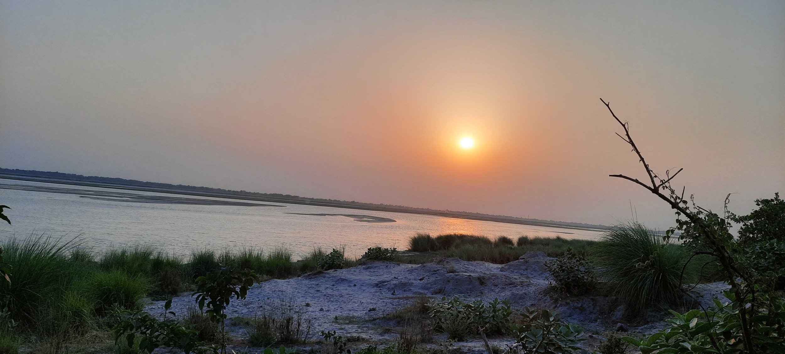
Sunset at the field site.

The next day we drove to the Valmiki Tiger Reserve at the India-Nepal border. The temperatures dropped slightly enroute to the reserve. After ten days of gazing at floodplains, we were then resting our eyes upon the Shivalik ranges at the horizon. We took a safari at the tiger reserve and it was calming to go around the trees. We spotted a number of avian beauties in the reserve - Emerald doves, Orange-headed thrush and the Paradise Flycatcher. Towards the end of the safari, we experienced mild showers, followed by hail stones. We rushed inside a temple complex to take shelter. Although brief, this little encounter with the temple was memorable. 

Author at the banks of the river Gandak. Nancy Alice/ TfW

The trip was a great learning experience for me and I am grateful for this opportunity. One of the greatest takeaways would be the discussions with my colleagues and collaborators about their journey through conservation and their love for the wild. While I reminisce over the memories of Gandak, I look forward to my next trip and hopefully as a trained drone pilot!

How-To: Carry UAVs through Indian airport security in 2022

TL:DR - Pack the UAVs in check-in luggage. Pack the controllers + batteries in cabin baggage. Empty out the contents of the cabin baggage into the tray while passing through security.


Note: This is a brief post describing our learnings regarding the transport of UAVs through Indian airport security in 2022. It is written in the hope that it helps other Indian UAV users navigate airport security without delay. I don’t think this will apply to non-Indian UAV operators, especially if they don’t present as Indian.


At Technology for Wildlife Foundation, one of our core operations is the use of robots (both Unmanned Aerial Vehicles and Unmanned Underwater vehicles) for conservation data acquisition purposes. For some projects, our partners send us data they’ve collected using their own devices. However, for others, it is imperative that we be on site with our equipment. This occasionally necessitates the transport of our robots across the country. For sites close to our base in Goa, India, we travel by either road or by rail. For these modes of transport, our primary concern is to package the equipment securely to avoid damage during transit. While traveling by air, however, we need to put much more thought into transporting our equipment.


As of November 2021, UAV users in India have a clear set of guidelines to follow, in the form of the Drone Rules 2021. As UAVs have become more mainstream, the security establishment is also formalising and mainstreaming processes around UAVs. To transport drones within the country, the Central Industrial Security Force (CISF), who manage security at most of India’s airports, now seem to have guidelines on how to process UAVs at domestic airport security checkpoints.  


Based on whether baggage is being carried in the cargo hold or in the passenger cabin, there are two categories of baggage on flights: cabin, which accompanies the passenger, and check-in, which goes into the hold. In brief, drone batteries and controllers (which contain fixed batteries) must be carried in the passenger cabin, while the drones themselves (without any batteries) must be carried in the cargo hold. If the controller batteries are removable, the controllers can also go into check-in baggage, which may be required depending on the size and weight of the controller. UAVs with fixed batteries cannot be carried on domestic airlines.


Pack the drones carefully, in a locked piece of luggage, as they will be out of sight passing through the luggage handling process, which can be rough on fragile items. The check-in luggage is deposited at the counter. In the past, with other robotic devices, we have informed the check-in staff that there are complex devices within the luggage. I personally have been called to check-in luggage security to verify what exactly the device is. Informing the check-in staff that the luggage contains UAVs without batteries is not required by regulations. While it may be helpful, it may also invite additional unnecessary scrutiny and is not something that we have felt the need to do regularly.


When going through security with our cabin baggage, we place every single piece of electronic equipment into the security tray that passes through the conveyor belt. When security staff have enquired as to the purpose of the devices, a straightforward answer of either “batteries”, or “drone batteries and controllers, but the drones have been checked-in”, has sufficed so far. We also carry paperwork that describes how the drones are to be used and have been used in the past; for us specifically, these consist of permission letters from the Forest Department.  


At some point in late 2021 or early 2022, posters depicting what cannot be carried as cabin baggage have been expanded to include drones as an additional item at the bottom of the poster. We’ll update this post with a photo of the poster the next time we have the opportunity. In the meanwhile, do let us know about your own experiences transporting UAVs by air in the comment section.

A day in the field: Chilling Tso and Ryul Tso (Ladakh Lakes #4)

On the morning of August 28, we left beautiful Korzok (by the banks of Tso Moriri) to survey Ryul Tso and Chilling Tso, the two most remote - and highest of the high-altitude lakes - that we had chosen to map using our underwater and aerial robots. These lakes are located to the east of Karzok and Tso Moriri and are separated from the lake only by a massif adorned by the peaks of Chamser Kangri, Lungser Kangri and Mentok Kangri. The weather over the last couple of days in Karzok had been largely kind, with bouts of light rainfall and gentle winds. Across the lake, however, angry-looking rainclouds had hung heavy over the Chamser, Lungser and Mentok peaks. Our (second) excellent driver and guide, Thopten, was constantly looking across at the clouds with not quite his usual smile, telling us that the bad weather was where we were headed, and expressing his doubts about the likelihood of us reaching the lakes without any trouble.

Dark clouds across Tso Moriri on the evening of 27th August.

Dark clouds across Tso Moriri on the evening of 27th August.

Our plan for August 28 was to head north from Karzok and drop off our bags at the monastery at Mahe, where Thopten had kindly asked his friends (the monks) to allow us to stay for a couple of nights, and who had, even more kindly, agreed. From Mahe, we would then head south-east, towards the high-altitude rangelands of the Changthang plateau, where our twin lakes lay. We freshened up at the toilet complex outside the monastery at Mahe, had some tea offered by the monks, and decided to push to the lakes and prayed fervently to the powers that be, for good weather.

The drive to Mahe, on a road lying alongside the Indus, was beautiful, flanked as we were by purple-hued peaks that seemed to made of little more than dirt at times, with patterns that reminded us that this barren land of high passes was once seabed. Marmots ran across the landscape, lugging their bottoms that were weighed down by the fat they were accumulating for the looming winter. Herds of kiang grazed, occasionally regarding us with a glance but not really fazed by the presence of humans at a safe distance. The cherry on the cake, however, were the pair of black-necked cranes we saw on the Indus floodplain, wading for food in the marshy grasses, mere feet beyond the road shoulder!

A pair of black-necked cranes on the highway

A pair of black-necked cranes on the highway

Passing through hamlets with golden-hued barley fields, the road eventually turned into a dirt track and then just flattened gravel. We paused briefly while a truck, carrying rations to the army camps up ahead, was repaired and then we went up into seemingly pristine hills without any permanent human habitation; and only the occasional military green tent to remind us that we were not the first to venture here. Up, up and into the widest expanse of land I have ever seen. At an an altitude of about 5000 m, we were flanked by towering peaks that appeared flattened by the distance they were at. Ryul Tso spread out before us, its expanse not visible at first because of the complete lack of any gradient in the land. White tents of the pastoral nomads dotted the landscape, mostly Changpas who had been camping at these lands for about three weeks now - pasturing their herds of prized pashmina goat and sheep.

Herds of pashmina goat and sheep on the shores of Ryul Tso

Herds of pashmina goat and sheep on the shores of Ryul Tso

We stopped a while from Ryul Tso. It was afternoon by now and the weather at  these altitudes is extremely unpredictable - we had to work fast. We surveyed the lake rapidly - the drone held up well under the able remote-piloting of Shashank, in spite of the high winds and the rarefied air. Tired, we trudged back to the car to carry on to Chilling Tso, which was still a half hour's ride away. Thopten surprised us all when we got to the car - he had arranged for refreshments. Tashi, a Changpa lady, invited us into her tent - where she served us Maggi, tea, fresh Pashmina butter and curd.

The view from Tashi’s tent

The view from Tashi’s tent

I am not a foodie, and I seldom relish a meal - but this assortment of fresh and fragrant rarities, and the kindness of our hosts who laboured in the harshest of worlds for their food, yet were willing to share it at the slightest sign of need - this will stay with me. Reinvigorated, we headed back into the car and south across the rangelands towards Chilling Tso for another set of rapid surveys.

Chilling Tso

Chilling Tso

The weather was becoming increasingly chilly, so we wrapped up work quickly and left for base. We made it back to the monastery in time for a hot meal at the gompa kitchen, and a hastily put-together serradura in a condensed milk tin with a matchstick as a candle to mark the end of our expedition and incidentally, the birthday of our expedition leader and my companion on many a mountain now, our beloved Shanks!

The author holding The World's Best Puppy in Mahe Gompa.

The author holding The World's Best Puppy in Mahe Gompa.