Mongabay-India

Conservation Cartography with Mongabay-India (Part V)

We began our collaboration with Mongabay-India to enhance their stories with our spatial analysis expertise. Our shared objective to diversify environmental awareness to communicate to a larger audience continues as we embark on our second year of collaboration.

From October 2021 to June 2022, we’ve worked together to produce 30 maps and map-related/cartographic media for 23 stories in 11 different verticals by Mongabay-India. This blog documents the final set of articles we visualised together from October 2021 to June 2022.

[Illustrations] Why are temperatures within a city’s neighbourhoods different?

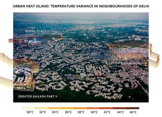
The minimum and maximum surface temperatures of three Delhi neighbourhoods with varying socio-economic and physical characteristics were taken around noon on May 3, 2021. The range of temperatures in a given neighbourhood is stacked in intervals of two degrees Celsius and represented in the illustration. Illustration by Alisha Vasudev/Mongabay.

Urban Heat Islands in a city can have different temperatures not only between the city and its surrounding areas, but within a city itself.

We gathered data from different neighbourhoods in Mumbai and Delhi, using Landsat 8 ST_B10 band and processed the data using Google Earth Engine. Alisha Vasudev/Mongabay has illustrated the range of temperatures in a given neighbourhood for recorded minimum and maximum surface temperatures at a given time, on a regular summer day in 2022.

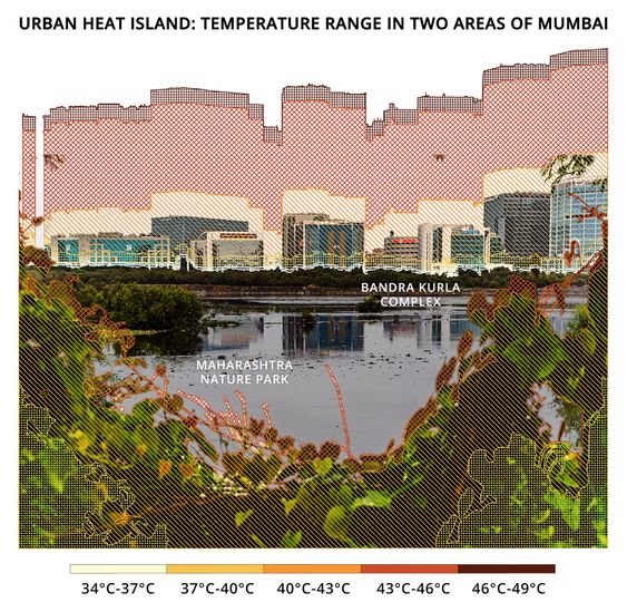
The minimum and maximum surface temperatures of two Mumbai neighbourhoods, with different physical characteristics, were recorded at 11 am on April 15, 2021. This illustration shows which temperature range (in intervals of three degrees) is recorded in what percentage of the area in each of these neighbourhoods. Illustration by Alisha Vasudev/Mongabay.

Maximum Land Surface Temperature in India, 01 March - 31 May 2022

According to experts, India's heat action plans need to incorporate long-term measures including efforts to decrease indoor temperatures, be regularly monitored and updated, and be more proactive to decrease heat stress.

(Note: This is the fifth blog in the series, on our collaboration with Mongabay-India. Read the previous blog here, and the first in the series, here.)

Conservation Cartography with Mongabay-India (Part IV)

In 2021, we began collaborating with Mongabay-India to enhance their stories with our spatial analysis expertise. Our joint goal is to use diverse storytelling formats to expand conservation awareness and reach a wider audience. This blogpost documents the fourth set of articles we’ve worked on together between May 2022 - July 2022

Corridors with high human activities may not ease elephant connectivity: study

This story draws attention to scientists' concern over genetic differences in elephant populations arising even over small distances separating them.

Click on image to explore some of the natural and human-made barriers to India’s elephants.

We worked on a map story highlighting existing elephant habitat ranges and fragmentation of degraded forests due to human establishments that hinder elephant connectivity.

When sand mining alters a river, flooding farmlands in Spiti

We created an animated map for this explainer on the transformation of Spiti river by illegal sand-mining in Spiti. The story also narrates the of the residents affected, and a general demand for a clarity in sand mining law in the valley.

Celebrating tiger numbers in Sathyamangalam Tiger Reserve, while tribal residents await their rights

Divisions in Sathyamangalam Tiger Reserve and the enclave villages surrounded by forests in the core and buffer areas.

Although Sathyamangalam Tiger Reserve (STR) tiger numbers are a cause to celebrate, the achievement has compromised the livelihood and land rights of indigenous people.

We worked on the map visualising divisions in STR overlaying the forest map for the reserve.

Fences of lemon trees keep elephants away from Assam farmers’ crops and homes

Mapping damage to built property in Assam by elephants in the state of Assam, in 2018-19.

The article traces the increasing use of biofences in India. During the migration period, elephants’ movement can damage crops and agricultural lands, leading to a rise in human-wildlife conflict in the area. Growing biofences based on local ecology, can maintain crucial elephant movement between fragments of their habitat, while doubling as a source of income habitants in the area.

We worked on maps visualising damage to property and crops by elephants in the state of Assam, in 2018-19.

Visualisation of crops (in bighas) damaged by elephants in the state of Assam, in 2018-19.

Distribution of Sarus Cranes in India and their range as defined by the IUCN RedList.

The article discusses a new study that has discovered a novel social unit among Sarus Cranes, where they now form trios to raise their offsprings. The authors also make a note of this behaviour being exhibited in degraded habitats, possibly as an effect of the rise in the loss of their habitat in India.

(Note: This is the fourth blog in the series on our collaboration with Mongabay-India. Read the previous blog here, and the first in the series, here)

Conservation Cartography with Mongabay-India (Part III)

In 2021, we began collaborating with Mongabay-India to enhance their stories with our spatial analysis expertise. Our joint goal is to use diverse storytelling formats to expand conservation awareness and reach a wider audience. This blogpost documents the third set of articles we’ve worked on together between March 2022 - May 2022

A decade on, India’s first solar park has many promises left to fulfil

The 5,384 acre Gujarat Solar Park in Patan.

The Gujarat Solar Park(GSP), India’s first utility-scale solar park, sets an example of how renewable energy development, if not done right, can lead to more environmental harm than good. The article discusses the socio-economic impacts of GSP, 10 years after its establishment.

Other solar parks in Gujarat’s Kutch district.

Citizen science data recorded at Mahatma Hill, Pune, on April 2, 2022.

Pune’s Mahatma hill, an offshoot of the Western Ghats, is home to around 129 species of resident and migratory birds, though recent years have seen a decline in their numbers. In the past two years, increased anthropogenic interference in the hill’s ecosystem are affecting the avian habitats here. 

We worked on a map collating information on bird diversity present in Mahatma Hill using iNaturalist data.

Expansion of windmills in Kachchh impact unique thorn forest and wildlife

OpenStreetMap data indicating 2053 windmills within Kachcch district in Gujarat.

Sangnara village in Kachchh depends mainly on agriculture and pastoralism for livelihood. The article brings forward the villagers’ interest that windmill projects planned within the village boundary be scrapped owing to the impact of windmills on Kachchh’s sensitive landscape- on local ecology, water sources and interpersonal relations.

We worked on the locator map for Sangnara and the location of other windmills in Kachchh.

The wind farm paradox in southern Tamil Nadu & Conserving biodiversity as wind farms expand in Tamil Nadu

Windmills in Tirunelveli district and near Muppandal in Kanyakumari district in southern Tamil Nadu.

Tamil Nadu is home to about 25 percent of India’s total wind energy capacity and remains an important part of India’s renewable energy target. The articles discuss the effect of the rising number of wind farms on biodiversity, and the social impacts of the same.

Wrong trees in wrong places wastes tree plantation budget, finds study

Tree planting is widely promoted as a natural solution to restore forests and absorb carbon from the atmosphere. India places heavy emphasis and budgets on tree planting in its global climate change goals. This article reports on the trend of planting the wrong trees in the wrong places, leading to financial losses.

(Note: This is the third blog in the series on our collaboration with Mongabay-India. Read the first blog here, and the second, here)